Cañada Lucero on Mesa Portales
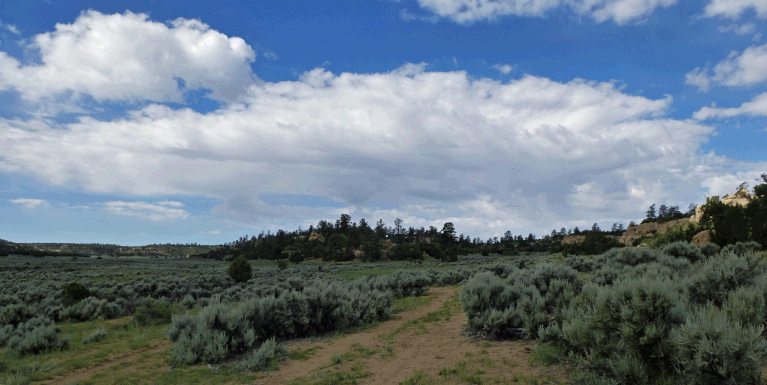
A hike on public land managed by the BLM, over gentle terrain, and further proof that Mesa Portales is worth checking out. For the elevation (6780 to 7050 feet), this hike includes a pleasing variety: junipers, piñons, and sage, of course, but also plenty of ponderosas and even aspens. There’s bare rock in the canyons and broad vistas on the mesas. The springs you’ll encounter raise the possibility of camping and exploring further. If you plan to wander off the described route, first check a land ownership map so you can avoid private inholdings.
To reach the trailhead, turn west on NM 197 at the south end of Cuba, N.M. The state road turns south to follow the Rio Puerco downstream, then bends to the west. About 4 miles from US 550 (at 35 deg. 58.392 min. N, 107 deg. 0.413 min. W), turn south (left) across a cattle guard and onto a dirt road. This road can get goopy when wet, and there are arroyos to drive across, so save the hike for dry weather.
The access road forks repeatedly. Bear right at fork 35 deg. 58.148 min. N, W 107 deg. 0.500 min. W, left at 35 deg. 57.824 min. N, 107 deg. 0.889 min. W, and right at 35 deg. 57.563 min. N, 107 deg. 0.993 min. W. You should now be on a two-track heading southwest. Cross an arroyo and stay on the two-track as it curls south, passing just east of a low mesa. Cross Arroyo Chijuilla at 35 deg. 57.075 min. N, 107 deg. 1.327 min. W. As soon you’re past the arroyo, the two-track curls west to avoid an embankment, then turns south. Pull off and park at 35 deg. 56. 841 min. N, 107 deg. 1.425 min. W.
To begin the hike, find the traces of a former two-track that heads WSW from the parking spot and zigzags up the slope. Top out at 35 deg. 56.770 min. N, 107 deg. 1.708 min. W, where you will find a sage-covered mesa top and a two-track. Follow the two-track more or less south, to 35 deg. 56.528 min. N, 107 deg. 1.908 min. W. Here you have two options. Option 1: to check out the head of the canyon to your left, continue south on the two-track you're on. At 35 deg. 56.271 min. N, 107 deg. 2.030 min. W, a cattle path splits off to the southeast. Follow the path 150 meters to the southeast and peer down into the canyon head, at a spring. Now cut WSW across the mesa top, through the sage, to 35 deg. 56.072 min. N, 107 deg. 2.506 min. W.
If you prefer not to bushwhack through sage, choose Option 2. Namely, back at the fork where I gave you the option, turn west (right) and use that two-track to cross the local mesa top. At 35 deg. 56.512 min. N, 107 deg. 2.433 min. W, turn SSW (left) onto a different two-track, and follow that.
Either way, at 35 deg. 56.072 min. N, 107 deg. 2.506 min. W you will encounter a gate. Pass through the gate and follow the two-track that leads down into a shallow valley, Cañada Lucero. Once down, turn south (upstream) while keeping close to the east edge of the valley bottom; pick up the local cow path if you can.
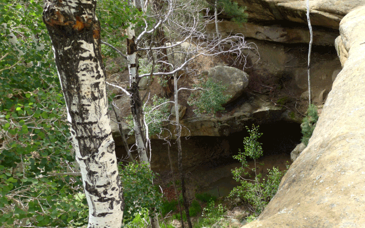
At 35 deg. 55.665 min. N, 107 deg. 2.654 min. W, the cow path passes through an old gate in a fence. Ahead of you the valley bottom forks; follow the cow path as it turns southwest and heads up the right-hand fork. Soon it will be easier to drop into the sandy arroyo bottom and follow that instead. A short distance to the right of the arroyo bottom, at 35 deg. 55.468 min. N, 107 deg. 3.113 min. W, is Ojo de Gutierrez. Behind it is an impressive overhang with a spring box. You could replenish your water supply here, but remember to purify before using.
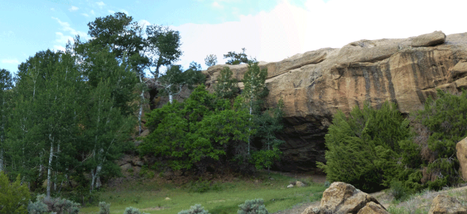
Now head southeast to rejoin the arroyo bottom. Continue upstream to 35 deg. 55.294 min. N, 107 deg. 3.003 min. W, where you’ll see a large alcove off to your right. If you head up the alcove you’ll find Smoky Spring, an even more plentiful source of (purifiable) water. Most likely you’ll also encounter the remains of an old herders’ camp. Disturbing cultural sites (even old cabins) or taking just one artifact (a shard of glass counts) is a crime, so take pictures and call it good.
About 400 meters south of Smoky Spring, the canyon forks and heads, at which point you can turn around and retrace your steps.
