Upper Virgin Canyon in the Jemez Mountains

Mostly an easy ramble (with one more challenging variation) among evergreens and aspens, high in the Jemez Mountains. A good warm-weather hike but even better when the aspens have turned to gold. A map of the hiking routes is provided at the end of this page. A hiking pole will come in handy for the route from VM VC2 to VM VC 3, but is optional otherwise. Near the parking spot you'll find plenty of evidence of motorized Neanderthals, so please bringing along a garbage bag and help clean up the area. As you keep hiking, the trash will drop off rapidly.
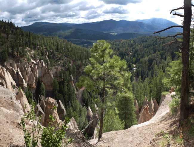
At the junction of NM 4 and NM 126 in La Cueva, set your trip meter to zero. Follow NM 126 out of La Cueva and turn left (south) onto FR 376 at 35 deg. 52.864 min N, 106 deg. 39.917 min. W (3.8 trip miles). Then turn left (southeast) onto FR 604 at 35 deg. 52.170 min. N, 40.412 min. W (5.0 trip miles). Continue to 35 deg. 51.975 min. N, 106 deg. 39.615 min. W (5.8 trip miles), pull over, and check out the tent rocks in the valley below you.
Continue on FR 604 as it loops sharply and heads uphill. Shortly after you reach the mesa top, ignore the turn to your left. Instead, continue toward
VM park: 35 deg. 51.698 min. N, 106 deg. 40.230 min. W (6.6 miles)
where you turn left into an informal campground on the southeast side of the road. Park here, and at the back of the camping area follow a two-track through the trees and downhill, toward
VM 1: 36 deg. 51.600 min. N, 106 deg. 40.216 min. W
You are now in the bottom of a shallow valley. Follow the two-track downstream (SSW), as the valley deepens and widens, and enjoy scenes such as the one that follows.

At the next waypoint you're a short distance above a large cattle tank. It's time to choose between routes, as is shown on the map at the end of the page.
VM 2: 35 deg. 50.721 min. N, 106 deg. 40.695 min. W (8330 feet)
Short Version (About 3 Miles)
From VM 2 angle right and uphill, onto an old road that will take you over the crest of the low ridge to the west. Once you reach the crest, one option is to turn right and hike north, along the top of the ridge, back to your car. This option is the dash-dot line shown on the map, beginning between VM 2 and VM 3. If you change your mind partway up the ridge, it's easy to drop off the ridge into the valley to the west -- but it's prettier to continue along the old road into the valley to the west, and turn right (north) at the next waypoint.
VM 3: 35 deg. 50.668 min. N, 106 deg. 40.917 min. W
You can continue up the valley all the way to FR 604, then turn east and follow FR 604 back to where you parked. A more pleasant alternative is to turn right (ENE) up a swale at
VM 4: 35 deg. 51.514 min. N, 106 deg. 40.591 min. W
onto a two track that rapidly dwindles into a cow path through the trees. The path will take you all the way back to where you parked.
Long Version (About 5 1/2 Miles)
Instead of leaving the local valley at VM 2, continue downstream past the large cattle tank. After a while the local two-track will be joined by another road coming in from the left. Continue to the confluence with Virgin Canyon, at
VM VC1: 35 deg. 50.075 min. N, 106 deg. 40.746 min. W (8160 feet)
This is a road junction. Turn downstream (SW) but don't take FR 607 as it starts climbing out of the canyon; instead take the two-track along the bottom of the canyon. About 900 meters downstream from the turn, at
VM VC2: 35 deg. 49.871 min. N, 106 deg. 41.222 min. W (8080 feet)
you have reached the low point of the hike, having lost almost 600 feet. Time to regain that elevation change. Turning right (north), leave Virgin Canyon and head up the side drainage, in the general direction of
VM VC3: 35 deg. 50.358 min N, 106 deg. 41.236 min. W
Between VM VC2 and VM VC 3 you'll be in a narrow valley bottom with some fallen trees, and the route varies from cow path to no path. In places you'll be walking up the stream bed, so this part of the hike should not be done when flash floods are possible. Above VM VC3 the valley bottom widens and you're back to a ramble. Proceed to VM 3. From there, use one of three available routes (VM 3 north, VM 2 north, or the ridge top between) to get back to the parking area.
