Tree Spring Trail in the Sandia Mountains
Most people drive to the top of the Sandias, using the Crest Highway. A few hike up from the bottom. For those who want something in between, the Tree Spring Trail [No. 347] is a popular route. The trail climbs 970 feet over two miles, with a great view of Albuquerque at its upper end. It’s a steady uphill walk and rocky in places, but casual hikers (and their many dogs) seem to have no trouble completing this one. It’s a non-wilderness hike, so watch for mountain bikes.
Despite its name, the Tree Spring Trail does not go to or past a spring. In a blog post I describe where Tree Spring actually is and how to find it. If you don't want to hike all the way to the top of the Sandias, you can park at the Tree Spring trailhead and do a roughly 1.2 km ramble to the spring.
The description that follows is for an in-and-out hike. From Albuquerque, drive east on I-40, north on NM 14, and partway up the east side of the Sandias on NM 536, the Crest Highway. Pull off into the trailhead parking lot on your left, at 35 deg. 11.633 min. N., 106 deg. 24.286 min. W (8480 feet). If you walk toward the pit toilets, you’ll see the start of the trail. Take the trail roughly southwest, to the junction with the upper end of the Oso Corredor Trail [No. 265], at 35 deg. 11.520 min. N, 106 deg. 24.494 min. W. Stay on the Tree Spring Trail as it continues upslope.
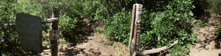
At 35 deg. 11.235 min. N., 106 deg. 25.248 min. W (9450 feet), you reach the upper end of the Tree Spring Trail. A sign and a short section of fence mark the edge of the Sandia Mountain Wilderness. Here you have three options for extending the hike. To head north along the 10K trail, make a right turn before the break in the fence. To follow the Crest Trail north, go through the break in the fence and continue uphill. To head south along the Crest Trail, go through the break in the fence and immediately make a left turn. Stop somewhere for lunch and retrace your steps to get back to the car.
Before following one of those trails, however, check out the overlook 140 meters southwest of the upper end of the Tree Spring Trail. To get there, go through the break in the fence and continue uphill to the crest of the ridge. The paths split and join, a possible source of confusion, but if you keep going uphill you’ll soon be there. Apparently many people are content to reach the overview, turn around, and hike back down the Tree Spring Trail—a four-mile, part-day hike.
