Chimney Canyon Loop via the Tramway Trail
As I write (March 2022), the Forest Service plans to shift the La Cueva Trail. The basic route should remain the same, however. Here I use that trail to provide access to the Tramway Trail, including for a small loop in the middle elevations of the western Sandias. This hike involves 1,565 feet of net elevation gain (and then loss). The route crosses slopes that in winter can be dangerously icy. Some trail junctions lack signs.
The hike begins in La Cueva Picnic Site—a great place to have lunch at a picnic table in the Sandia foothills. To reach the trailhead, head either north or east on Tramway (if you live in Albuquerque, that’s not confusing). Where Tramway makes its big bend, turn off on FR 333. About 400 meters later, turn right on FR333B to enter the picnic site. Ignore the first two right turns. At the pit toilets, take the third right turn, then pull off to the right and park at 35 deg. 12.265 min. N, 106 deg. 29.242 min. W (6540 feet).
La Cueva Trail (492) begins across the road, in the wash. Head east and north to the junction with the Tramway Trail (82) at 35 deg. 12.334 min. N, 106 deg. 29.008 min. Turn left onto the Tramway Trail and head roughly NE, then north. At 35 deg. 12.374 min. N, 106 deg. 28.914 min. W, you’ll cross the bottom of La Cueva Canyon. Ignore the unofficial trail that forks right and heads up the canyon. Instead, take the left fork and continue on the Tramway Trail, mostly north, climbing steadily.
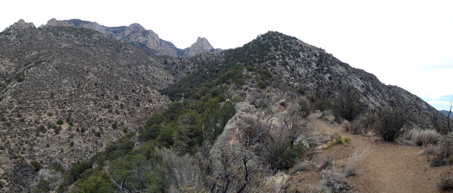
At 35 deg. 12.863 min. N, 106 deg. 28.842 min. W the Tramway Trail reaches the lip of Chimney Canyon and bends sharply right (SE). The trail now follows the north-facing slope of the ridge. (About 50 meters before you reach the ridgeline, a sketchier trail branches off and mostly stays on the south-facing slope of the ridge. Eventually it rejoins the route I describe, but I recommend continuing to the ridgeline before making your right turn.)
At 35 deg. 12.783 min. N, 106 deg. 28.663 min. W, you reach another fork (“Begin Loop”). You can take the left fork to join the La Luz Trail (137). Instead, make a U-turn to the right (onto Trail 137B). About 30 meters later, on the ridgeline, make a U-turn to the left. At 35 deg. 12.722 min. N, 106 deg. 28.230 min. W, you’ll return to the ridgeline. Probably the best lunch option for this hike is in this area (for example, at the rocks about 150 meters to the southwest). About 50 meters NNE, at 35 deg. 12.744 min. N, 106 deg. 28.217 min W, is the junction between Trail 137B and the La Luz Trail. This is the high point on the hike, at 8105 feet.
Once at the La Luz Trail, turn left and cruise down the switchbacks. At 35 deg. 12.815 min. N, 106 deg. 28.538 min. W, a big sign is your clue to turn off the La Luz Trail, cross the bottom of Chimney Canyon, and head back to “Begin Loop.” Once there, retrace your steps to the La Cueva Picnic Site and your vehicle.