Sulphur and Alamo Canyons in the Valles Caldera
On a summer holiday weekend the established campgrounds in the Jemez Mountains are jammed, and parking lots are overflowing. On those same days, if you walk into the Valles Caldera National Preserve you'll have alpine valleys all to yourself. Fires have torched parts of the preserve, but this part is still a bit of paradise. Hard to believe that such a gorgeous place, so close to large towns, sees so little use.
The local hiking routes follow graded roads and two-tracks, so a great place for beginning hikers or small kids. And with perhaps one pickup truck driving by all day, the routes don't feel like roads; they feel more like deluxe hiking trails where friends can walk (and talk) two or three abreast.
This is just one of many hiking options in the Valles Caldera National Preserve. You can learn about the local hiking guide at this web site. Be sure to check the VCNP web site for current regulations before visiting the preserve. For now (2017) you don't need a permit if you park outside the preserve boundary and day hike from there.
To reach the starting point, head north on NM 4 from San Ysidro, through Jemez Springs. Shortly after the NM 126 turnoff at La Cueva, NM goes into a big rightward hairpin curve. Near the apex of the curve (at 35 deg. 52.630 min. N, 106 deg. 37.973 min. W), turn left (north) off NM onto a graded road (not well signed, so use your GPS to find the turn). About 190 meters in, the road forks; ignore FR 106 headed left and uphill and follow FR 105 as it heads up Sulphur Creek. Drive slowly through the residential area for about a mile, then up the wooded canyon for about a mile more. The locked gate at the preserve boundary is at 35 deg. 54.222 min. N, 106 deg. 37.267 min. W. Use the wide spot just shy of the gate to turn around, and pull off on the west shoulder of the road about 60 meters south of the gate. There's enough room for about three cars to park there without interfering with road traffic. Your starting elevation is 8110 feet.
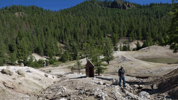
To begin the hike, crawl under the gate and follow the road up canyon. Less than a half mile in you'll encounter Sulphur Springs, a barren area of abandoned buildings, abandoned vehicles, and bubbling springs and steam vents. For those who enjoy cavorting naked, bad news: there's nothing skinny-dippable. A visitor to this web page has informed me that about 1990, one John Corbin lived at Sulphur Springs and had a large-scale magic mushroom operation going there. Corbin dried his mushrooms in the abandoned cars, on sheets of newspaper.
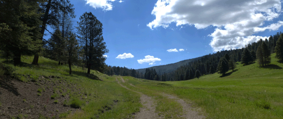
Having absorbed this bit of New Mexico history, continue past the moonscape on the road. Soon you'll be in the gentle alpine country that makes the Jemez Mountains a rambler's delight. At 35 deg. 55.167 min. N, 106 deg. 36.176 min. W, you'll face a pleasant dilemma: whether to continue straight on the road up Sulphur Canyon, or turn right (east) and head up Alamo Canyon. On this occasion, let's turn right.
Alamo Canyon contains ponds, bubbling springs, and a live trickle of a stream, so a very pretty walk. Once you get far enough up the canyon, the two-track is unused and grassed over. You can make a fine lazy day of it by following the two-track up the canyon, lunching under aspens, and retracing your steps (downhill all the way!) back to your car.

Suppose that instead of turning right or east (into Alamo Canyon) you continue from the intersection straight up Sulphur Canyon. At 35 deg. 6.277 min. N, 106 deg. 35.432 min. W you'll encounter another fork in the road. If you take the left fork you'll go over an easy pass and wind up at San Antonio Creek, about 2.3 miles NNW (as the crow flies). There's a back country road in that valley, though, so if it's solitude you seek, turn right. Now you're in the Valle Seco, a broad and very pretty meadow. Ramble up the valley, pick a place for lunch, and ramble back for a lovely in-and-out hike.

You can combine the Alamo Canyon and Valle Seco options into a loop hike. First I'll assume a clockwise loop. Once at the east end of the Valle Seco, at 35 deg. 56.175 min. N, 106 deg. 33.813 min. W, continue southeast into the trees and uphill. The road takes you to the upper east slope of the north-south ridge at the east end of the Valle Seco. At 35 deg. 56.214 min. N, 106 deg. 33.345 min. W, the road bends south while continuing its gentle climb. At 35 deg. 55.159 min. N, 106 deg. 33.447 min. N, at a saddle, it's time to leave the road. Head about 55 meters northwest, to the trailhead shown below. As you cross the saddle you're at the high point in the hike, 9410 feet.

At first the trail behind the sign is easy to miss. DO NOT assume that the trail heads down the local drainage, and that you can follow the drainage until you pick up the trail. (If you do, you'll wind up back in the Valle Seco. Eventually.) Instead, bear left relative to the drainage and pick up a faint, completely overgrown former two-track that traverses and slowly descends the local north-facing slope. The farther you go, the more obvious the trail becomes. The east end of the trail doesn't show on Google Earth so to help you along, here are a few waypoints:
35 deg. 55.209 min. N, 106 deg. 33.606 min. W
35 deg. 55.260 min. N, 106 deg. 33.824 min. W
35 deg. 55.110 min. N, 106 deg. 34.055 min. W
the last being a saddle overlooking the head of Alamo Canyon. From there the old road drops quickly into the canyon and you're on the obvious two-track that will take you to where Alamo and Sulphur Canyons meet.
If you do the loop counterclockwise, you shouldn't have problems finding the east end of the Alamo Canyon Trail. Just follow the two-track in Alamo Canyon eastward as it climbs past the head of the valley. You'll pass the listed waypoints and trailhead sign and will arrive at an obvious road at a saddle. Turn left on the obvious road and follow it, mostly northward, as it slowly descends to the east end of the Valle Seco.
Once you leave Alamo Canyon or Valle Seco to do the loop, you'll be crossing into recently burned areas. They're greening rapidly, and there are some great views, so the loop hike is worth doing.
Alamo Canyon is one place where I'm not tempted to purify and drink the water, even though it's everywhere. You'll get whiffs of sulfur again and again in that valley, and the water must have a lot of dissolved minerals. Even if it's safe to drink after filtering (which I don't know), water that sulfurous might have serious laxative qualities.