Slick Rock Country via Marquez Wash
If you love the slick rock country in the Four Corners, you’ll find a patch of what you love during this hike. An easy ramble, mostly, but with sandstone ledges and shale slopes to navigate. The access road and parts of the hike cross shale-derived soils, so don’t attempt the hike after heavy rains or snows.
From US 550 near San Ysidro, turn onto Cabezón Road. Follow the road all the way to the gas pipeline compressor station, where Cabezón Road turns right (northwest) and follows the gas pipeline. Turn right as well. Fifteen meters shy of 35 deg. 30.208 min. N, 106 deg. 57.446 min. W, you’ll cross a cattle guard, and a corral will be off to your right. Pass through the cattle guard, make the right turn, and take the two-track past the south side of the corral. You'll need to let yourself through an unlocked wire gate; be sure to close it after you pass.
Park under the power line to begin the hike. (You can continue beyond the power line if you have a good back-country vehicle—but the whole point is to be hiking, right?) Walk northeast along the two-track, on the northwest side of Marquez Wash, to 35 deg. 30.653 min N, 106 deg. 56.620 min. W. Here a break in the fence leads into the wilderness area. (If you insisted on driving as far as possible, you’ll park somewhere around here.)
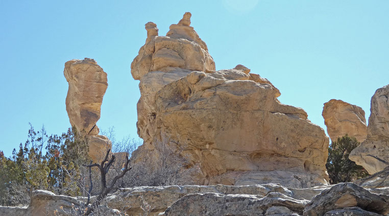
After passing through the break in the fence, follow a cow path northwest (don’t follow the fence, but angle away from it), to 35 deg. 30.808 min. N, 106 deg. 56.734 min. W (“Begin Loop”). You’re now at the edge of Arroyo Bernalillito, and from this point on the hike involves cross-country navigation. Work your way north across the uneven arroyo bottom and head to 35 deg. 31.086 min. N, 106 deg. 56.654 min. W, where you will encounter an arroyo with a sandy bottom. Follow the arroyo bottom upstream, passing left (west) of a low bluff, to 35 deg. 31.475 min. N, 106 deg. 56.652 min. W. On the way you'll pass to the left of a rock formation that reminds me of a duck.
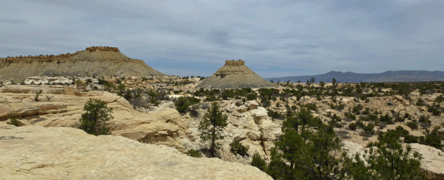
The terrain in the first part of the hike could be almost anywhere in the Ojito Wilderness, but that’s about to change. Continue east from the waypoint, following the arroyo bottom a few steps, but then take a small side arroyo and climb up and out to get out of the arroyo bottom (if you go too far up the main drainage, you’ll wind up in a miniature box canyon). You’re on the right way up if you locate the rock formation show below, head toward it, and pass to its left.
Once on top, you’re in a playground of sandstone slick rock, white sand, junipers, and pines. Some of the pines are ponderosas, which are small and struggling at this low elevation (6000 feet) compared to up in the mountains. Still, it’s not hard to find a tree to sit under when you’re ready for lunch.

The local terrain is forgiving enough to let you explore as you wish (and the hike in is short enough that you’ll have plenty of time to do that). My version of the hike circumnavigates a butte with dark shale sides, first passing west of it (headed north) then east of it (headed south). Northeast of the butte is my favorite part of the slickrock area. It's possible to circle the butte and go down where you went up (at the rabbit and carrot) but I prefer to head south, keeping east of the butte, and scramble down somewhere. If you go up and over the sandstone mesa to the south, the easiest way off that mesa goes past a ponderosa at 35 deg. 31.292 min. N, 106 deg. 56.510 min. Bear left from there for the final drop into the valley bottom.* Once back down in the Arroyo Bernalillito, navigate to the “Begin Loop” waypoint to complete the loop, and retrace your steps to your car.
During this hike you’re likely to encounter abandoned ranch buildings. Keep in mind that it’s illegal to disturb them or take any of the artifacts you find there. Instead, take pictures and think about the people who lived or worked there, generations ago.

*In 2022 I instead passed to the right of that sandstone mesa, and dropped down at an arroyo head at 35 deg. 31.304 min. N, 106 deg. 56.589 min. W.