North Faulty Trail
In Sandia Mountain Hiking Guide, Mike Coltrin calls this trail the North Mystery Trail. He remarks that it was created by persons unknown, and only later added to the official Forest Service trail system. The trail is now clearly marked as the Faulty Trail, with that trail's number (195). Someone is maintaining the trail, primarily by removing fallen trees, and it gets a fair amount of use. The trail has has some up-and-down and is rocky in places, but that makes the trail feel wilder than many in the Sandias. The North Faulty Trail is fairly low down, so best saved for the spring or fall. If you do hike it mid-summer, at least it's shady.
To reach the trail, drive up the Crest Road (NM 536) past the Doc Long picnic area. Just before the road goes into a hairpin turn to the left, pull off the road to the left and park, at 35 deg. 10.883 min. N, 106 deg. 22.625 min. W (elevation 7470 feet). Cross the road (be careful of drivers zooming around the curve) and walk about 50 meters uphill to the sign marking the start of the trail. From there follow the trail north, up a valley, to a saddle at 35 deg. 11.267 min. N, 106 deg. 22.675 min. W (7680 feet). Some people head up the bottom of the valley to the saddle, so there's a parallel trail that works fine when the weather is dry.
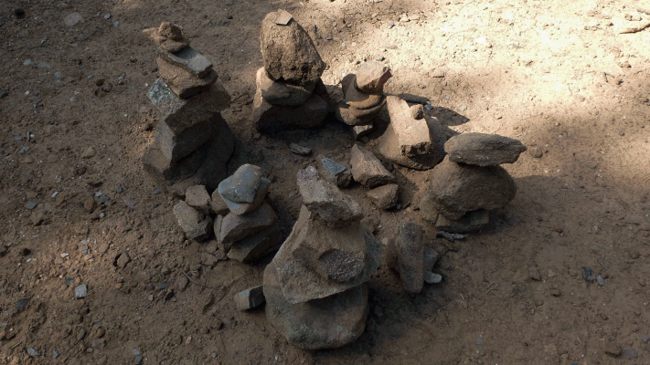
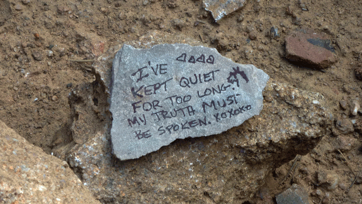
Whichever path you took to get there, once you're at the saddle the trail bends left (west and southwest) and climbs before resuming its northerly trend. (If you follow the abandoned road north and down from the saddle, you'll dead-end at private property. ) Once you finish the climb, the North Faulty Trail takes you north to a flattish spot and clearing at 35 deg. 11.726 min. N, 106 deg. 23.038 min. W (7920 feet). In September 2017 we found a personal shrine at this location. (That probably temporary landmark is shown below.) If you're looking for a short hike, this might be a good spot to take a break and then turn around.
As you keep moving north, you'll see a lot of "dog hair"—small, thickly clustered trees—with many dead trees among them. Not the prettiest part of the Sandias, and a prime area for a wildfire. But you'll also see nicer areas, and a few vistas through breaks in the trees. At 35 deg. 12.438 min. N, 106 deg. 23.274 min. W (7930 feet) you'll reach another saddle, after which the trail descends into Madera Canyon. If you're planning to retrace your steps, you'll have a climb back out of the canyon, so you may wish to turn back no later than here. If you do continue north on an in-and-out hike, shortly after crossing under the power line to the Crest you'll encounter a large flat outcrop of sandstone (at 35 deg. 12.804 min. N, 106 deg. 12.190 min. W; 7590 feet). On a cool day, it might make sense to lunch in the sun on the outcrop before turning around.
Once past the outcrop you'll continue downward until the trail bends into the bottom of Madera Canyon, at 35 deg. 12.936 min. N, 106 deg. 23.267 min. W (7380 feet). This was where we lunched in September 2017. At the time there was no water in the creek at the trail crossing but about 20 meters downstream, I found a pool with clear water in it. Admittedly, when I filtered and drank the water, it tasted and smelled a little skanky.
After lunch at Madera Canyon we turned around and went back the way we came. By my GPS it's 3.5 miles from the parking area to where the trail crosses Madera Canyon, so a 7.0 mile trip. Mike Coltrin recommends doing this as a one-way hike, which involves continuing past Madera Canyon and coming out at the Palomas Cliffs trailhead, for a total distance of 5.2 miles (please see his book for the details). The next time, I think, I'll follow Coltrin's advice.