Mesita Blanca near Tohajiilee

A short, easy hike on public (BLM) land not far west of Albuquerque, in a pocket-sized gem of a landscape. The hike is based on an ASCHG loop hike but the best part of their route was the first part, with ventanas (natural rock windows), tent rocks, and hoodoos. I'll list that part as an in-and-out hike (about 4 miles round trip). You can find the Youtube video of that hike here. At the end of this page is a partial loop option that should add to your enjoyment of the place.
The hike should be avoided in wet weather. Much of the access route is unpaved, and the hike itself crosses a major wash. There's no trail and lots of low-growing cactus, so I recommend leather boots even though the hike is easy.
From Albuquerque, drive west on I-40 and turn north at the Tohajiilee exit. At 35 deg. 5.812 min. N, 107 deg. 6.661 min. W, just before entering the school complex, turn right over a cattle guard and immediately turn left onto an unpaved road. Set your trip meter to zero. Stay on the main road as it heads NNE, ignoring various turnoffs. Just after the route veers NNW at about mile 3.0, the road forks at 35 deg. 8.457 min. N, 107 deg. 5.695 min. W. Bear right, staying on the main road.
At 35 deg. 11.596 min. N, 107 deg. 6.228 min. W (about mile 6.8), you reach a T marked by a lonely street sign. Turn left (northwest) and continue 0.4 mile to 35 deg. 11.900 min. N, 107 deg. 6.498 min. W (about mile 7.3). There, a two-track dirt road turns off to the right (northeast). If your car isn't made for two-tracks, park here. Otherwise, turn onto the two-track and continue about 280 meters to a side road at 35 deg. 12.027 min. N, 107 deg. 6.400 min. W. Turn right onto the side road, immediately pull off that road, and park.
Begin the hike (if you haven't already) by heading along the side road, more or less east. The road soon bends left, follows a wash down to the Cañada del Ojo, and bends right along that wash. As the two-track peters out, cross the wash and head to the red rock outcrops at 35 deg. 12.120 min. N, 107 deg. 5.830 min. W. Begin exploring north along the spine of red rock. Almost immediately, you'll need to crawl under a fence. Just west of (next to) the spine is an easy place to do that. Head to 35 deg. 12.314 min. N, 107 deg. 5.696 min. W, and follow that edge of the ridge northward as you gaze at tent rocks.

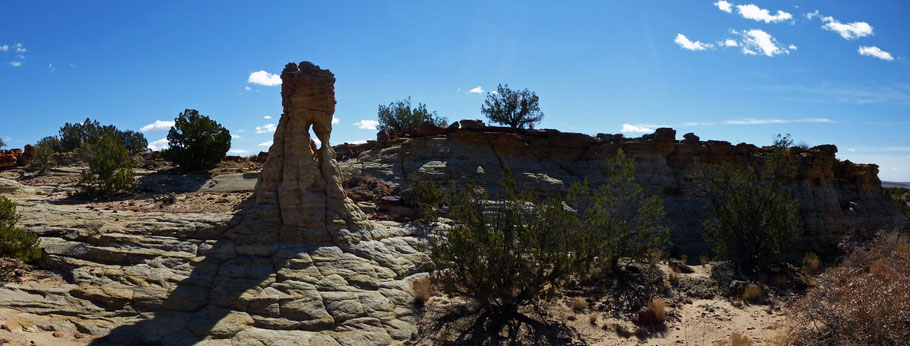
Once past the tent rocks, follow a cow path with a low bluff of white rock just to your right. At 35 deg. 12.500 min. N, 107 deg. 5.574 min. W, you have two options. One is to continue northeast about 50 meters, until you're off the low bench rimmed with red rocks. The other is to turn right and find the easy route to the top of the bluff, then follow the top edge of the bluff northeast until the bluff peters out. Either way, once you're back in easy terrain it's time to strike out through the junipers to the prominent isolated hoodoo at 35 deg. 12.798 min. N, 107 deg. 5.443 min. W. A raptor nest halfway up the hoodoo was empty when we visited (mid-March 2018). If the nest is in use when you visit, please give the residents a wide berth.

From the hoodoo, head to the walk-through ventana at 35 deg., 12.863 min. N, 107 deg. 5.395 min. W., then a short distance farther to 35 deg. 12.891 min. N, 107 deg. 5.367 min. W. There, in a little rockbound valley, I saw something I'd never seen before: a hoodoo with a ventana. Afterwards, you can continue northward to the last gasp of the red rock outcrop, at 35 deg. 13.057 min. N, 107 deg. 5.306 min. W. Here the in-and-out version of the hike ends, so begin retracing your steps along the rock spine and back to your car.
To make a partial loop of this hike, take the route described above but during the return, change your route back. From the isolated hoodoo with raptor nest, or thereabouts, head to 35 deg. 12.459 min. N, 107 deg. 5.356 min. W. There you'll find an easy descent into the local valley. Explore as you wish but drift SSW, to base of the local mesa tip at 35 deg. 12.240 min. N, 107 deg. 5.587 min. W. Turn NNE (right) and you'll find yourself among the hoodoos you gazed at earlier. After exploring them, head west and up onto the low ridge (there are several places to do that), closing the loop. Once on the ridge, follow your footsteps back to your car.