Gonzales Mine from the Quebradas Byway
(To see a YouTube video of this hike, click here.)
The Quebradas Backcountry Byway takes you off pavement and into hills east of the Rio Grande near Socorro. The byway provides access to many square miles of undeveloped country that’s begging to be hiked. I picked up this specific hike from the Albuquerque Senior Center Hiking Group web site, and liked it so much that I’ll include it here with modifications. Part of the hike follows a wash bottom, so don’t do the hike when flash flooding is possible.
Heading south from Albuquerque on I-25, turn off at the Lemitar exit and cross east over the freeway into Lemitar. Half a mile from the freeway, turn south (right) at Severo Vigil Street onto NM 408. This turn is not well marked so I'll provide coordinates: 34 deg. 9.573 min. N, 106 deg. 54.602 min. W. If you see the local church on your left, you've gone too far.
Once on NM 408, continue south about 3 miles, then take a left at 34 deg. 7.170 min. N, 106 deg. 53.549 min. W, onto Chaparral Loop, which becomes Pueblitos Road. Cross the Rio Grande. On the far side of the river is a T intersection (at 34 deg. 7.302 min. N, 106 deg. 52.733 min. W) where your options are to turn left or right or to continue into a private driveway. Turn right. After about 160 meters the main road will curl left (east). Follow this road (Bosquecito Road) as it then curls right (south) and heads down the valley.
At 34 deg. 6.645 min. N, 106 deg. 52.304 min. W, turn left (east) to start the unpaved Quebradas Backcountry Byway. You’ll be driving the byway for a while, first mostly east, then mostly south. At 34 deg. 5.016 min. N, 106 deg. 46.803 min. W, the byway crosses Arroyo Tinajas. If you’re sure there will be no flash floods that day (famous last words), the best place to park is on the stream bed just upstream (east or left) of the crossing. Otherwise, find a parking spot that’s out of the arroyo bottom. Given the “bar ditches” on either side of the road, you may have to drive a way before finding a suitable pull-off spot.

To begin the hike, follow the arroyo bed downstream (southwest). At 34 deg. 4.041 min. N, 106 deg. 47.949 min. W, a two-track road leaves the arroyo. Just downstream, the arroyo plunges down a short, narrow canyon. If you turn back here, it’s a roughly 4 mile round trip. Instead, take the two-track north and west, out of the local valley. About 200 meters after leaving the wash, while heading uphill, you’ll pass to the left of the La Bonita Prospect. Once past the prospect the road levels out and heads mostly north. As a check on your route, at 34 deg. 4.488 min. N, 106 deg. 48.228 min. the two-track crosses a large wash.

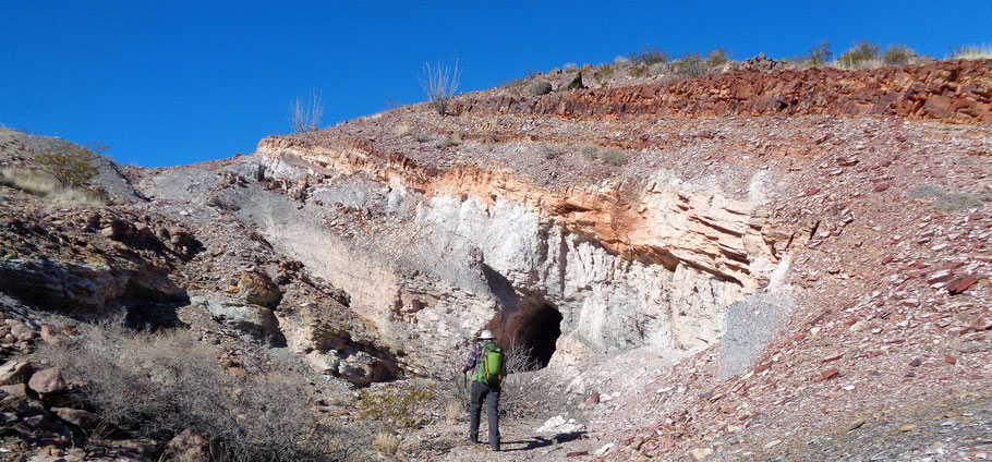
At 34 deg. 4.951 min. N, 106 deg. 48.379 min. W, you will encounter the Gonzales Mine (or Prospect), which features fluorite and barite deposits. Based on an online report, a short-lived attempt to exploit this claim and the La Bonita Prospect took place during World War II. Like all mines with open workings, this one poses dangers. After lunch, retrace your steps to complete the hike, covering about 6 1/2 miles in all. Or make a loop of it by following the rest of this guide. The loop version is actually shorter, about 5 1/2 miles, but involves cross-country navigation.

To exercise the loop option, continue north along the same road you followed to the Gonzales Mine. Once you climb a small valley to the local flats, about 34 deg. 5.160 min. N, 106 deg. 48.400 min. W (and about 400 meters beyond the mine), turn right off the road and head to 34 deg. 5.238 min. N, 106 deg. 48.313 min. W. There you will pick up a bend in a faint path. Take the turn to the right (northeast and uphill). The path soon turns southeast, then back northeast to zigzag up to a saddle on a ridge. This path is part of the Cerrillos del Coyote mountain bike loop, which as of January 2019 showed little evidence of recent use. If the bike loop fades out entirely, it should still be possible to do this part of the hike as a cross-country segment.
The bike path reaches the saddle at 34 deg. 5.289 min N, 106 deg. 48.140 min. W. Stay on the path as it continues northwest, on the southwest side of the ridge crest. At 34 deg. 5.371 min. N, 106 deg. 48.211 min. W, you’ll reach a second saddle. The bike path continues along the ridge, but leave it and drop down into the valley on the far side of the ridge. Don’t go down through the notch directly below you. Instead, angle down to the notch to your right. If you reach 34 deg. 5.362 min. N, 106 deg. 48.120 min. W, you’re at the top of the notch you want to use to descend. As you do that, stay to the right of the actual arroyo.
Once in the valley bottom, keep right of the incised main arroyo while heading toward the bushy juniper at 34 deg. 5.299 min. N, 106 deg. 47.868 min. W. Once past that point, however, cross the arroyo as soon as you can and head to 34 deg. 5.148 min. N, 106 deg. 47.563 min. W. There, take advantage of a shallow arroyo to crawl under an east-west fence. Once past the fence, keep it on your left (i.e., head more or less east) but be sure to stop at 34 deg. 5.130 min. N, 106 deg. 47.274 min. W to admire the fossils exposed in limestone bedrock by the local arroyo.

After that, return to your initial waypoint (where the byway crosses the Arroyo Tinajas). This final segment of the hike can be a bit tricky. If you attempt a beeline route, you’ll soon be staring down bluffs flanking the arroyo. Instead, head left of the bearing to the waypoint (i.e., only slightly south of east) until you’re past the bluffs, then make a gentle descent to the Arroyo Tinajas.
