Embudito Trail in the Sandias

The Embudito Trail will take you to Oso Pass, South Sandia Peak, and other points in the southern Sandia Mountains. Here I’ll describe a shorter in-and-out hike. The hike involves a long uphill stretch going in, on an uneven and sometimes rocky trail, so not a good choice for small children. On the way back I was glad to have both hiking poles with me. The trail begins at the edge of Albuquerque (so no long drive to get there) and quickly takes you into a wilderness area. To get to the trailhead, take Montgomery east from Tramway and turn left at Glenwood Hills Drive. Turn right on Trailhead Road and continue to the parking lot at the end of the street.
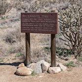
The Embudito Trail begins on the north side of the lot, at 35 deg. 8.172 min. N, 106 deg. 28.918 min. W (6430 feet) and immediately turns right to head up Embudito Canyon. About 300 meters in (at 35 deg. 8.199 min. N, 105 deg. 28.726 min. W), turn left (north) to follow the Embudito Trail as it climbs out of the valley bottom and along the north slope of the valley. The turn is marked by the sign in the photo. (If you ignore this sign and continue straight, you’ll soon reach a narrow canyon. It's possible to scramble up the canyon bottom, working your way past brush, but it's slow going.)
Once at the bare flat spot at 35 deg. 8.065 min. N, 106 deg. 28.428 min. W, the trail dissolves into a confusing series of paths. Coltrin writes, "Looking toward the south, one or two paths go over the rise, and you will see that they start heading down toward the canyon bottom. You want to take the branch just to the left of those paths and head uphill past a large boulder. It is easy to take the wrong fork here, because the paths appear almost equally worn." (This language appears in both editions of the book.)
The problem is, it's easy to bear too far to the left, following some minor sort-of-path, and miss the proper trail. You can muddle through until you find the trail again, but it's much easier to use the correct route. The photo that follows will guide you past the confusing spot. (As of the spring of 2019, recent trail maintenance has made the proper path more obvious, but it's still good to be aware of the problem.)
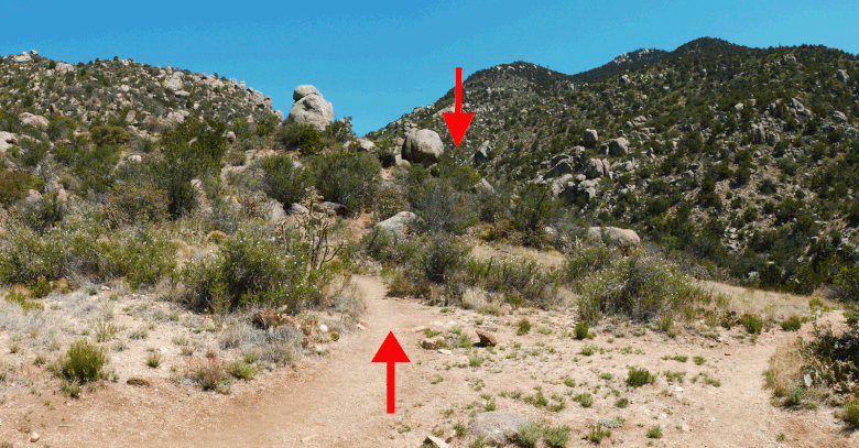
Part of the confusion may be because as you look up canyon with Coltrin's advice in mind, you face two prominent boulders, not one. As you first step away from the bare spot, head between the two boulders (upward pointing arrow). But don't head past the more prominent boulder on the left, even though there are impromptu paths that encourage you to do so. Instead, head to the right of (and just downslope from) the less prominent boulder to the right (downward pointing arrow).
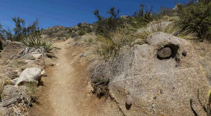
Also, about 150 meters past the boulders shown above, look for the boulder shown below. Because of the prominent xenolith (darker rock) eroding from the granite, it should be easy to spot. At that boulder make a sharp left and head on up the switchback; don't continue straight ahead. If you make this turn, the rest of the route should be much more obvious.
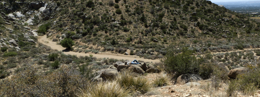
Once you’re past the boulder shown above, the trail turns into a steady uphill slog. Moreover, this part of the trail is on a south-facing slope with limited shade, so it could get toasty in the summer. The uphill slog ends about 35 deg. 7.992 min. N, 106 deg. 27.595 min. W (7480 feet), where you’ll find shade for hot weather, sunny boulders to sit on in cool weather, and views of South Sandia Peak. By this point in the hike, you’re 1000 feet higher than when you started. If you don’t have the time for a longer hike, it’s a good place to have lunch and turn around.

This is also the high point of the hike as described; immediately beyond, the trail enters tall trees as it drops (about 100 vertical feet) into the bottom of Embudito Canyon. It reaches the bottom about 35 deg. 7.915 min. N, 106 deg. 27.368 min. W (7385 feet) and wanders upstream from there. In Sandia Mountain Hiking Guide Mike Coltrin states, “I think this is one of the most beautiful areas in the Sandia Mountains.” Eventually the trail climbs out of the canyon bottom, to Oso Pass and beyond, but I haven’t bothered going beyond the canyon bottom—it’s a great place to have lunch before turning around.
In May 2019 I encountered a seasonal spring (fed by the previous winter’s snowfall) in the canyon bottom. Don’t count on finding water along the hike, however. If you do find any, be sure to purify before drinking.