Loop Hikes of the Doc Long-Sulphur Canyon-Cienega Canyon Area

When you need a Sandias woodland fix but don't want to drive all the way up the Crest Highway, the area just inside the national forest boundary provides many options for loop hikes. The trails can be muddy or icy, but often remain passable for hiking when higher trails are buried in snow. The roads to the trailheads are paved, and picnic tables and pit toilets abound. You can use this area for everything from a picnic with toddlers to serious hikes.
Let's start by looking at a trail map prepared by the Friends of the Sandia Mountains. If you click on the thumbnail below, you'll be taken to their web site for the high resolution version. I'll also provide a mid-resolution version, if for some reason the external link doesn't work. BTW, the Wagon Trail (228) now extends all the way from Cienega Canyon to Sulphur Canyon.
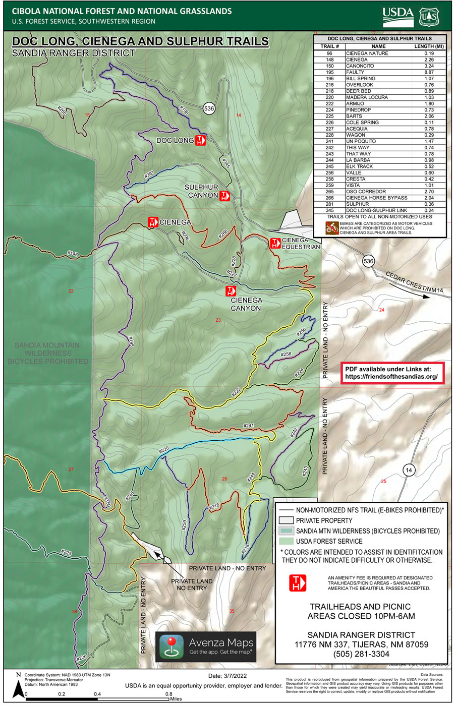
The basic idea is that you turn off at one of two places—Sulphur Canyon or the Doc Long picnic area—and create a loop hike based on how ambitious you're feeling. In the cool months, much of the road system in Sulphur and Cienega Canyons is closed to vehicle traffic, but the added walking is minimal.
I'll provide a couple of specific options, but don't let that stop you from crafting a route of your own. As a rule, the official trails in this area are well-marked, easy to follow, and not that steep or rocky.
- My Bill Spring Trail loop hike involves parking at the Doc Long picnic ground, heading up the Bill Spring Trail, turning south onto the Faulty Trail, heading down Sulphur Canyon, and returning to Doc Long via the Doc Long-Sulphur Link Trail.
- My Armijo Trail loop hike involves parking in Cienega Canyon (if the gates are open), heading up the Armijo Trail, turning north onto the Faulty Trail, and heading down Cienega Canyon.
If you ever wondered how the Doc Long picnic ground got its name, check out this blog.
While this page is built around official routes in the Sulphur Canyon-Cienega Canyon area, there's also at least one unofficial route you can explore—what I have dubbed the Old Fence Trail.