Challenge Trail in the Sandia Mountains

For years I didn't consider the Challenge Trail (2330 when looking for new places to hike in the Sandia Mountains. Two reasons for that. First, the trail parallels the Crest Highway (NM 536) and I don’t like being near road noise. Second, I thought the Challenge Trail was an up-and-down trail, and as an older hiker I prefer trails not dominated by steep grades. I’m here to say that with one proviso, the Challenge Trail is worth checking out.
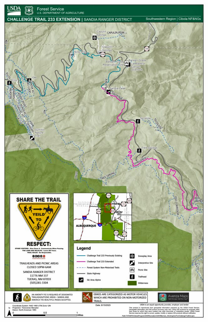
Including a recent extension, the Challenge Trail extends from the Bill Spring Trail to the Ellis Trail, about 9.2 miles. I'll provide the Forest Service trail map at the end of this page. The grades along the trail are very manageable, averaging under 300 feet a mile. There are level stretches along the way, and much of the trail follows old road beds—a great formula for easy hiking. Most of the time, the Crest Highway isn’t visible from the trail; instead you pass through woods and meadows. On weekends and holidays, the traffic on the Crest Highway is noisy, mostly due to the motorcycles snorting their way up and down the mountain. Also, tracks I’ve seen in the trail suggest that peak mountain bike use of the trail is heavy. During weekdays, neither the motorbikes nor the mountain bikes are much in evidence, so you can enjoy some peace and quiet despite being so close to the road.

Multiple parking areas provide access to the Challenge Trail. I'll list the ones I've used, from bottom to top.
1. To start at the bottom of the trail, park in the Doc Long picnic area and head up Bill Spring Trail to the junction with the Challenge Trail.
2. Park at the Tree Spring Trailhead and walk up that trail about a third of a mile before hanging a right. From there to the bottom of the ski area is about 1.7 miles. (To continue on the Challenge Trail, you cross about 0.2 mile of the ski area while paralleling the highway.)
3. Park at the bottom of the ski area, next to the highway, and walk up to the upper parking lot (usually closed). From there to the Capulin Springs Picnic Ground and snowplay area is about 1.1 miles.
4. Park at the Capulin Springs Picnic Ground, cross the highway, and head a few meters upslope until you intercept the Challenge Trail. The obvious path up from the road begins a bit downhill from the turnoff into the picnic ground. From there to the 10K trail is about 2.3 miles. Along the way you'll pass through the Nine Mile picnic area, which is closed but is being remodeled, so hopefully will be open soon.
5. To start at the 10K trailhead, park in the south side parking lot (to your left as you head up the mountain). Start on the trail at the southeast (downhill) end of the parking lot, and almost immediately take the right fork (the left fork is the southbound 10K Trail). A few meters later, take the right fork again. From there it's about a mile to the upper end of the Challenge Trail.
6. The trail ends at the Ellis Trailhead. If you want to continue to the very top of the mountain, other trails allow you to do that.