The San Ysidro Anticline from the South
If you're looking for a textbook anticline, you can't do better than this one. You'll also see massive gypsum deposits (there's an active mine nearby) and travertine springs and domes. Enhance your experience by learning about the geology beforehand, including at this web site. Your explorations will be made easier by the network of well-marked mountain bike trails. Please reciprocate by stepping off the path for bike riders.
The access road for the hike crosses shale and should not be attempted after heavy rain or snow. The trails can become slick as well. Hiking poles aren't needed everywhere, but will come in handy.
From Bernalillo, head northwest on US 550. Just before the Rio Jemez bridge and San Ysidro, turn left on Cabezón Road. Immediately take the left fork to continue on that road. At 35 deg. 29.895 min. N, 106 deg. 50.465 min. W, turn right and park in the formal parking area. To begin the hike, follow the two-track northeast out of the parking area.
About 70 meters out the route splits; take the right fork (the main two-track) and continue northeast. After another 150 meters the two-tack makes an S-curve, curling east and then north. Continue to 35 deg. 30.246 min. N, 106 deg. 50.293 min. W, where the two-track forks. Take the right fork, which heads northeast and then east, for about 300 meters, then follow the rim of the anticline north. At 35 deg. 31.148 min. N, 106 deg. 50.369 min. W the marked trail splits left off the two-track. Continue north along the trail until it rejoins the two-track, which you follow northwest and down onto the central ridge of the anticline.
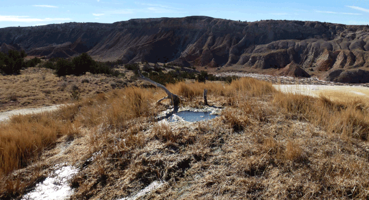
At 35 deg. 31.450 min. N, 106 deg. 50.703 min. W, one branch of the two-track heads north and the other heads south. Begin by following the north branch. At 35 deg. 31.547 min. N, 106 deg. 50.752 min. W, be sure to turn onto the side path that takes you to the ridge line just to the west. Once on the ridge line climb the rise just to the south to see a classic example of a travertine dome, then drop down along the ridge line to cross a travertine seep spring. (The water in the local springs has a high mineral content so don't drink it, even after purification.) If you continue north along the two-track, you will be able to visit other travertine formations.
Once finished exploring along the north branch of the two-track, return to where it branched (at 35 deg. 31.450 min. N, 106 deg. 50.703 min. W) and follow the other branch south. This two-track runs right past the travertine spring shown at the top of the page. If you climb the rise southeast of the spring, you'll see a fairly spectacular example of a travertine dome (but avoid the edges, which are undercut). As you continue south, the two-track dwindles into a one-track and drops off the central ridge. To complete the hike, you need to cross the valley bottom and hike up the ridge shown in the photo below.
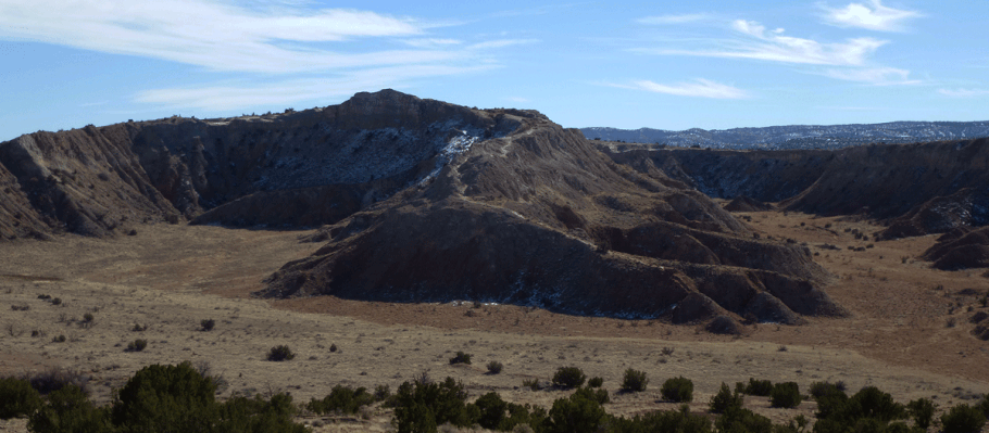
Once you reach the base of the ridge shown above, at 35 deg. 30.678 min. N, 106 deg. 50.553 min. W, don't head up the obvious "chute"; that's for bicyclists headed downhill. Instead, cut to the right and follow the trail up the back of the ridge toe. Also, part of the way up you'll come to a sort of gully carved out of the gypsum, leading straight up the ridge, while a fairly well-beaten path turns off to the right. Ignore the path and scramble up the gully, so that you stay on the ridge line.
Once you've topped out, head left and visit the local peak for a panoramic view. Catch the two-track at 35 deg. 30.407 min. N, 106 deg. 50.329 min. W and follow it downhill for an easy, leisurely final leg of the hike. At 35 deg. 30.246 min. N, 106 deg. 50.293 min. W you'll complete the loop portion of the hike (on the way in, you took the right fork of the two-track at this spot) and from there it's just a matter of retracing your steps to the car.